AWS Public Sector Blog
Capella and SpaceNet deliver unique views of Earth with machine learning on AWS
SpaceNet LLC is a nonprofit organization dedicated to accelerating open source artificial intelligence applied research for geospatial applications, specifically foundational mapping (i.e. building footprint and road network detection). SpaceNet is run in collaboration with CosmiQ Works, Maxar Technologies, Intel AI, Amazon Web Services (AWS), Capella Space, Topcoder, the IEEE Geoscience and Remote Sensing Society, the National Geospatial-Intelligence Agency, and Planet Labs.
The breadth of challenges that can be addressed by overhead imagery is broad and continues to grow as new and improved sensors are deployed. To make the best use of this data, you need to have high-quality training data—data that you know is true (often called ground truth data) so that your algorithms can learn from it. A lack of this high-quality labeled training data continues to impede progress in many areas of remote sensing analytics, including machine learning. Two of the SpaceNet collaborators, Capella Space and Amazon Web Services (AWS), are providing access to a unique dataset to help foster innovation in geospatial-based artificial intelligence.
Earth observation data with Capella Space
Capella Space is an aerospace and information services company that provides on-demand very high-resolution Synthetic Aperture Radar (SAR) Earth observation imagery. Through a constellation of small satellites and an entirely automated imagery tasking and order experience (through an easy-to-use web application and API), Capella is providing easy access to frequent, timely, and flexible information affecting dozens of industries worldwide. Capella’s satellites use AWS to downlink data (AWS Ground Station), process it (AWS Batch), and deliver (Amazon Simple Storage Service (Amazon S3)) reliable global insights about commerce, conservation, and security on Earth.
SpaceNet 6 Challenge
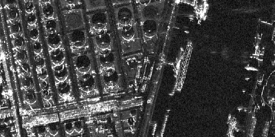
This year, SpaceNet held its sixth challenge, focused on pushing the boundaries for multi-sensor, all-weather mapping. SAR is a unique form of radar that can penetrate clouds, collect data during all-weather conditions, and capture data day and night. Overhead collects from SAR satellites could be particularly valuable in the quest to aid disaster response in instances where weather and cloud cover can obstruct traditional electro-optical sensors (like your camera, but in space). However, despite these advantages, there is limited open data available to researchers to explore the effectiveness of SAR for such applications, particularly at ultra-high resolutions. The task of SpaceNet 6, which had over 1,600 submissions, was to automatically extract building footprints with computer vision and artificial intelligence (AI) algorithms using a combination of SAR and electro-optical imagery datasets.
Capella collected X-band Synthetic Aperture Radar data near Rotterdam, Netherlands. The data was collected from 8:00 AM to 8:00 PM over two days, six times each day, to simulate roughly one-hour revisit at high resolution. The main features in the areas of interest are: the port, ships (tankers and commercial), shipping containers, cars, parking lots, a stadium, train tracks, floating lid oil tanks, downtown infrastructure, and vegetated areas.
The winner of the SpaceNet 6 Challenge was zbigniewwojna, followed by MaksimovKA and SatShipAI. The top five competitors in the challenge each received a portion of the total $50,000 cash prize, with first place winning $20,000. The winning algorithm achieved a score of 42.423, representing a 74% increase over the baseline solution. The winners were able to successfully adapt state-of-the-art AI and computer vision algorithms to automatically extract building footprints from very-high resolution SAR data. The algorithms showed marked improvements in speed over previous challenges, with the winning algorithm able to make predictions at a rate of 5.4 seconds per km2 using an AWS p3.8xlarge instance.
Dataset now available
According to SpaceNet general manager Ryan Lewis, “In the geospatial domain, there is a dearth of labeled datasets for either drone or satellite imagery. The first step in creating a research community is making sure that there are high-quality, curated data available, not just to one program, but to everybody.” The SAR data for the SpaceNet 6 Challenge is now available via the Registry of Open Data on AWS. To gain access to more high-resolution SAR imagery like this, join Capella’s SAR developer community.
Find out more about how SpaceNet accelerates geospatial learning using AWS in the video below. Stay tuned for details on how to participate in the next SpaceNet 7 Challenge, taking place this summer, and learn more about how our customers are using AWS for their geospatial workloads at Earth on AWS.