SpaceNet 3: Road Network Detection
The Problem
 The commercialization of the geospatial industry has led to an explosive amount of data being collected to characterize our changing planet. One area for innovation is the application of computer vision and deep learning to extract information from satellite imagery at scale. CosmiQ Works, Radiant Solutions and NVIDIA have partnered to release the SpaceNet data set to the public to enable developers and data scientists to work with this data.
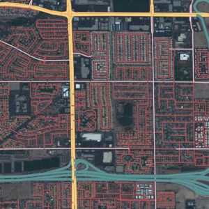
Today, map features such as roads, building footprints, and points of interest are primarily created through manual techniques. We believe that advancing automated feature extraction techniques will serve important downstream uses of map data including humanitarian and disaster response, as observed by the need to map road networks during the response to recent flooding in Bangladesh and Hurricane Maria in Puerto Rico. Furthermore, we think that solving this challenge is an important stepping stone to unleashing the power of advanced computer vision algorithms applied to a variety of remote sensing data applications in both the public and private sector.
RELATED BLOGS
- SpaceNet Roads Extraction and Routing Challenge Solutions are Released
-
Creating Training Datasets for the SpaceNet Road Detection and Routing Challenge
-
Introducing the SpaceNet Road Detection and Routing Challenge and Dataset
-
SpaceNet Road Detection and Routing Challenge Part II — APLS Implementation
- SpaceNet Road Detection and Routing Challenge — Part I
The Data – Over 8000 Km of roads across the four SpaceNet Areas of Interest.
See the labeling guide and schema for details about the creation of the dataset
| AOI | Area of Raster (Sq. Km) | Road Centerlines (LineString) |
|---|---|---|
| AOI_2_Vegas | 216 | 3685 km |
| AOI_3_Paris | 1,030 | 425 km |
| AOI_4_Shanghai | 1,000 | 3537 km |
| AOI_5_Khartoum | 765 | 1030 km |
Road Type Breakdown (km of Road)
| Road Type | Vegas | Paris | Shanghai | Khartoum | Total |
|---|---|---|---|---|---|
| Motorway | 115 | 9 | 102 | 13 | 240 |
| Primary | 365 | 14 | 192 | 98 | 669 |
| Secondary | 417 | 58 | 501 | 66 | 1042 |
| Tertiary | 3 | 11 | 34 | 68 | 115 |
| Residential | 1646 | 232 | 939 | 485 | 3301 |
| Unclassified | 1138 | 95 | 1751 | 165 | 3149 |
| Cart track | 2 | 6 | 19 | 135 | 162 |
| Total | 3685 | 425 | 3537.9 | 1030 | 8677 |
Catalog
aws s3 ls s3://spacenet-dataset/spacenet/SN3_roads/
Sample Data
10 Samples from each AOI – Road Network Extraction Sample
To download processed 400mx400m tiles of AOI 2 (728.8 MB) with associated road centerlines for training do the following:
aws s3 cp s3://spacenet-dataset/spacenet/SN3_roads/tarballs/SN3_roads_sample.tar.gz .
Training Data
AOI 2 – Vegas – Road Network Extraction Training
To download processed 400mx400m tiles of AOI 2 (25 GB) with associated building footprints for training do the following:
aws s3 cp s3://spacenet-dataset/spacenet/SN3_roads/tarballs/SN3_roads_train_AOI_2_Vegas.tar.gz .

aws s3 cp s3://spacenet-dataset/spacenet/SN3_roads/tarballs/SN3_roads_train_AOI_2_Vegas_geojson_roads_speed.tar.gz .
AOI 3 – Paris – Road Network Extraction Training
To download processed 400mx400m tiles of AOI 3 (5.6 GB) with associated road centerlines for training do the following:
aws s3 cp s3://spacenet-dataset/spacenet/SN3_roads/tarballs/SN3_roads_train_AOI_3_Paris.tar.gz .

aws s3 cp s3://spacenet-dataset/spacenet/SN3_roads/tarballs/SN3_roads_train_AOI_3_Paris_geojson_roads_speed.tar.gz .
AOI 4 – Shanghai – Road Network Extraction Training
To download processed 400mx400m tiles of AOI 4 (25 GB) with associated road centerlines for training do the following:
aws s3 cp s3://spacenet-dataset/spacenet/SN3_roads/tarballs/SN3_roads_train_AOI_4_Shanghai.tar.gz .

aws s3 cp s3://spacenet-dataset/spacenet/SN3_roads/tarballs/SN3_roads_train_AOI_4_Shanghai_geojson_roads_speed.tar.gz .
AOI 5 – Khartoum – Road Network Extraction Training
To download processed 400mx400m tiles of AOI 5 (25 GB) with associated road centerlines for training do the following:
aws s3 cp s3://spacenet-dataset/spacenet/SN3_roads/tarballs/SN3_roads_train_AOI_5_Khartoum.tar.gz .

aws s3 cp s3://spacenet-dataset/spacenet/SN3_roads/tarballs/SN3_roads_train_AOI_5_Khartoum_geojson_roads_speed.tar.gz .
Testing Data
AOI 2 – Vegas – Road Network Extraction Testing
To download processed 400mx400m tiles of AOI 2 (8.1 GB) for testing do:
aws s3 cp s3://spacenet-dataset/spacenet/SN3_roads/tarballs/SN3_roads_test_public_AOI_2_Vegas.tar.gz .
AOI 3 – Paris – Road Network Extraction Testing
To download processed 400mx400m tiles of AOI 3 (1.9 GB) for testing do:
aws s3 cp s3://spacenet-dataset/spacenet/SN3_roads/tarballs/SN3_roads_test_public_AOI_3_Paris.tar.gz .
AOI 4 – Shanghai – Road Network Extraction Testing
To download processed 400mx400m tiles of AOI 4 (8.1 GB) for testing do:
aws s3 cp s3://spacenet-dataset/spacenet/SN3_roads/tarballs/SN3_roads_test_public_AOI_4_Shanghai.tar.gz .
AOI 5 – Khartoum – Road Network Extraction Testing
To download processed 400mx400m tiles of AOI 5 (8.1 GB) for testing do:
aws s3 cp s3://spacenet-dataset/spacenet/SN3_roads/tarballs/SN3_roads_test_public_AOI_5_Khartoum.tar.gz .
Citation Instructions
If you are using data from SpaceNet in a paper, please use the following citation:
Van Etten, A., Lindenbaum, D., & Bacastow, T.M. (2018). SpaceNet: A Remote Sensing Dataset and Challenge Series. ArXiv, abs/1807.01232.
Metric
In the SpaceNet Roads Challenge, the metric for ranking entries is the APLS metric. This metric is based on graph theory and empahsizes the creation of a valid road network.
The current version of the metric is open sourced on github: Average Path Length Similarity (APLS) metric For more information read the SpaceNet Road Detection and Routing Challenge Series, Part 1, and Part 2, written by Adam Van Etten at The DownlinQ.
For more information read the full article written by Adam Van Etten at The DownlinQ.
License

The SpaceNet Dataset by SpaceNet Partners is licensed under a Creative Commons Attribution-ShareAlike 4.0 International License.
 The commercialization of the geospatial industry has led to an explosive amount of data being collected to characterize our changing planet. One area for innovation is the application of computer vision and deep learning to extract information from satellite imagery at scale. CosmiQ Works, Radiant Solutions and NVIDIA have partnered to release the SpaceNet data set to the public to enable developers and data scientists to work with this data.
 The commercialization of the geospatial industry has led to an explosive amount of data being collected to characterize our changing planet. One area for innovation is the application of computer vision and deep learning to extract information from satellite imagery at scale. CosmiQ Works, Radiant Solutions and NVIDIA have partnered to release the SpaceNet data set to the public to enable developers and data scientists to work with this data.