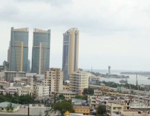
Datasets // Dar Es Salaam
SpaceNet AOI 10 – Dar Es Salaam
Download Instructions
To be released post-challenge.
SpaceNet Simple Storage Service (S3) Directory Structure (AOI 10)
To be released post-challenge.Accelerating Geospatial Machine Learning
To be released post-challenge.
To be released post-challenge.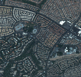 Determining optimal routing paths in near real-time is at the heart of many humanitarian, civil, military, and commercial challenges. This statement is as true today as it was two years ago when the SpaceNet Partners announced the SpaceNet Challenge 3 focused on road network detection and routing. In a disaster response scenario, for example, pre-existing foundational maps are often rendered useless due to debris, flooding, or other obstructions. Satellite or aerial imagery often provides the first large-scale data in such scenarios, rendering such imagery attractive.
The SpaceNet 5 challenge sought to build upon the advances from SpaceNet 3 and test challenge participants to automatically extract road networks and routing information from satellite imagery, along with travel time estimates along all roadways, thereby permitting true optimal routing.
The task of this challenge was to output a detailed graph structure with edges corresponding to roadways and nodes corresponding to intersections and end points, with estimates for route travel times on all detected edges. You can find a detailed description of CosmiQ Works’ algorithmic baseline on their blog at The DownLinQ.
SpaceNet open sourced new data sets for the following cities: Moscow, Russia; Mumbai, India; and San Juan, Puerto Rico. For the first time in SpaceNet history, the final submissions were tested on a mystery city dataset that was revealed and open sourced at the end of the Challenge.
The first 20 competitors to reach a score of 50 (out of a possible 100) received a credit for 10 hours on a p3.2xlarge for training and improving their models. To further aid competitors, the SpaceNet 5 baseline is fully open source, and yields a score of 54. If you have any questions, please reach out through the Topcoder Forum (https://www.topcoder.com/challenges/30099956).
| AOI | Area of Raster (Sq. Km) | Road Network Labels (Km) |
|---|---|---|
| AOI_7_Moscow | 1,353 | 3,066 |
| AOI_8_Mumbai | 1,021 | 1,951 |
| AOI_9_San Juan | 285 | 1,139 |
| AOI_10_Mystery City | ??? | ??? |
aws s3 ls s3://spacenet-dataset/spacenet/SN5_roads/
To download processed ~400mx400m tiles of AOI 7 with associated road network labels for training do the following:
aws s3 cp s3://spacenet-dataset/spacenet/SN5_roads/tarballs/SN5_roads_train_AOI_7_Moscow.tar.gz .To download processed ~400mx400m tiles of AOI 9 for public testing do the following:
aws s3 cp s3://spacenet-dataset/spacenet/SN5_roads/tarballs/SN5_roads_test_public_AOI_9_San_Juan.tar.gz .
To download processed ~400mx400m tiles of AOI 8 with associated road network labels for training do the following:
aws s3 cp s3://spacenet-dataset/spacenet/SN5_roads/tarballs/SN5_roads_train_AOI_8_Mumbai.tar.gz .To be released after the conclusion of the challenge.
Post-challenge releaseThe SpaceNet Partners, “SpaceNet5: Automated Road Network Extraction and Route Travel Time Estimation from Satellite Imagery”, https://spacenet.ai/sn5-challenge/

The SpaceNet Dataset by SpaceNet Partners is licensed under a Creative Commons Attribution-ShareAlike 4.0 International License.
Catalog ID: 104001002B3BB400
Image Time: 2017-04-05
To view the contents of the dataset
aws s3 cp s3://spacenet-dataset/spacenet/SN5_roads/tarballs/SN5_roads_test_public_AOI_9_San_Juan.tar.gz .
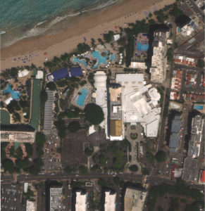
├── AOI_9_San_Juan
│   ├── MS      		# Tiled geotiffs of 8-Band Multi-Spectral raster data from WorldView-3
│   ├── PAN     		# Tiled geotiffs of Panchromatic raster data from Worldview-3
│   ├── PS-MS			# Tiled geotiffs of 8-Band Multi-Spectral raster data pan-sharpened to 0.3m
│   ├── PS-RGB			# Tiled 8-bit color-corrected geotiffs of RGB raster data from Worldview-3 pan-sharpened to 0.3m
The path to the processed ~400mx400m tiles of AOI 9 with associated road network labels for training is:
s3://spacenet-dataset/spacenet/SN5_roads/tarballs/SN5_roads_test_public_AOI_9_San_Juan.tar.gz